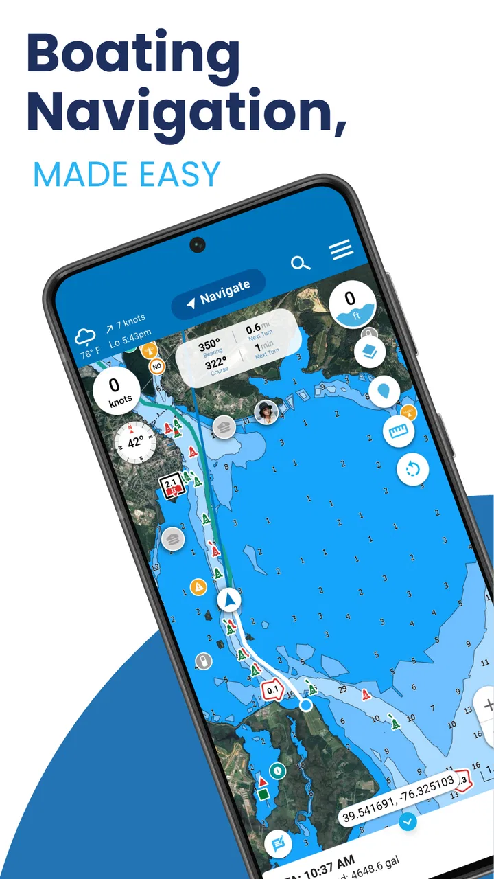
Argo - Boat Navigation App
- 4.2
- Rating
- 100.00K
- Installs
- Free
- Price

 Analysis by App-foxy
Planning a day on the water is very different from checking a route on a normal road map. A useful marine app has to bring together charts, weather, tides, trip notes, and navigation tools without making the preparation itself feel like another job. After spending time with Argo, I found it most appealing as a practical planning companion for boaters who want several parts of a trip in one place rather than a collection of disconnected tools.
Argo is a free Maps & Navigation app from Argo Technologies, LLC. Its focus is clearly marine use: NOAA charts and maps, weather, tides, boat trip planning, a logbook, and NMEA support are all part of the experience. It has reached over 100 thousand installs and holds a 4.2 average from around 1 thousand ratings, which suggests a healthy level of interest without making it feel like an app everyone is expected to use.
My overall impression is that it works best before and during a trip when I want to move from “Where should I go?” to “What did I actually do?” in a reasonably connected workflow. It is less convincing as a universal replacement for every dedicated instrument on a boat. That distinction matters: Argo can make preparation more organized, but responsible navigation still depends on current information, sound judgment, and proper backup equipment.
You May Also Like

 Blood Strike: 2.5 Anniversary
Blood Strike’s Loadouts Turn Every Drop Into a Tactical Gamble
A close look at Blood Strike’s custom loadouts: how fast access to signature weapons reshapes its battle royale rhythm, rewards preparation, and narrows the gap between fights.

 Pandora - Music & Podcasts
Pandora’s Music Is Easy to Start, but Harder to Recover
Pandora’s strength is its low-effort path from a seed to a station. Its weak spot is how much confidence it asks you to place in connection, setup, and quiet recovery.

 8 Ball Pool
 Is Built on Rivalries, Rematches, and Routine
A close look at the rivalries, rematches, shared routines, and unanswered safety questions that turn a quick pool match into a persistent mobile community.

 Samsung Music
’s Quiet Strength Is Playing What You Already Own
Its reach comes less from spectacle than from dependable access to a personal library. That simplicity is both the app’s strongest retention engine and its ceiling.

 AccuWeather: Weather Radar
AccuWeather Review: A Quick, Clear Forecast for Everyday Decisions
For everyday plans, the best forecast is the one you can understand quickly. AccuWeather makes rain timing, radar, and local conditions easy to act on, with a few trade-offs.

 Hill Climb Racing
Why Hill Climb Racing Still Turns Crashes Into One More Run
A tiny car, a bumpy hill and one more upgrade: Hill Climb Racing keeps resurfacing because its simple chaos makes every near-miss feel personal.
More From Our News Desk



From a vague boating idea to a usable plan
Before I draw a route, I like to turn a loose idea into a few practical decisions: where I want to go, what conditions could change the plan, and what would make me head back early. That preparation is especially useful when a trip is still flexible, because it gives me something concrete to discuss with the crew rather than treating the first destination as a commitment.
The starting condition: a trip that still exists mostly in your head
I would open Argo at the point when a boating plan is still informal. Perhaps I know the launch area, have a destination in mind, and want to decide whether the outing makes sense for the available time and conditions. Instead of jumping directly into a route, I can first think about the trip as a combination of location, timing, weather, and water conditions.
That combination is where a marine-focused app has an advantage over a general map application. A conventional mapping tool may be excellent for reaching a marina by car, but it is not designed around nautical charts, tide changes, or a boat log. Argo puts those concerns closer together, so the planning process feels more relevant to what happens after the trailer leaves the road or the boat leaves the dock.
The NOAA chart and map material is especially important here. I would use the chart view to understand the shape of the area and the relationship between the planned destination and nearby water features. I would not treat a screen as permission to ignore local notices, visual conditions, or the boat’s own equipment. The useful role is to give me a clearer planning picture before I commit to a route.
Weather and tides also belong at this early stage, not as an afterthought. A destination that looks comfortable on a map can become a poor choice when the timing of the tide or the expected weather changes. Argo’s value is that these questions sit inside the same boating workflow instead of forcing me to switch repeatedly between a chart app, a weather service, and handwritten notes.
Building the route one decision at a time
Once I have a general destination, the boat trip planner becomes the practical center of the process. I would use it to turn a broad idea into a route that I can review before departure. The important habit is to pause after creating the route and inspect it as a plan rather than assuming that drawing a line has solved the navigation problem.
This is one of the first non-obvious strengths of the app: planning is useful even when I do not follow the route exactly. A route gives me a shared reference for the people traveling with me. If the weather changes or the group decides to turn back, I still have a starting point for explaining what changed. That is more useful than relying on a vague memory of the intended destination.
I would also prepare a simple alternative before leaving. The app is not valuable only when everything goes according to plan; it is more useful when I have already considered a shorter outing, a return point, or a nearby place to pause. Preparing those options in advance reduces the temptation to make rushed decisions while underway.
For a family outing, this workflow might begin with a short trip to a familiar area. I could check the chart, review weather and tide information, plan the route, and then keep the intended destination visible to everyone onboard. If the children become uncomfortable or the weather looks less inviting than expected, the original route still helps me choose a sensible point to shorten the trip rather than improvising from scratch.
Weather and tides as route decisions, not decoration
It is easy for weather panels in navigation apps to become something I glance at once and forget. I found Argo more useful when I treated the information as a reason to adjust the plan. The question is not simply whether the forecast looks good. It is whether the conditions suit the boat, the people onboard, the timing, and the specific route I have chosen.
Tide information can change the practical meaning of a route as well. A plan that works comfortably at one part of the day may need more care later. I would check it before departure and again when deciding whether to extend the outing. This is a small workflow change, but it prevents the common mistake of treating the departure forecast as a permanent description of the whole day.
There is also a useful trade-off here. Keeping charts, weather, and tides together saves time and reduces app switching, but it can encourage overconfidence if I assume that one screen represents the complete situation. I still want to compare what the app shows with local knowledge and the conditions I can actually observe. Argo supports preparation; it does not remove the responsibility to interpret what is happening around the boat.
The handoff from planning to the boat
The most important handoff is from the app to the person making decisions onboard. Before departure, I would review the route with whoever is helping operate the boat. That conversation matters because a route stored on a phone is not automatically a shared plan. Everyone should understand the destination, the likely return approach, and what would cause us to change course.
This is also where I would think about device placement and attention. A phone-based navigation tool is convenient, but the person driving should not be constantly staring down at a screen. I prefer using the app to prepare and confirm decisions, then keeping observation, lookout duties, and normal boat handling in the foreground. The app should support the crew, not become the crew’s only source of awareness.
Argo’s NMEA support adds another possible handoff between the app and onboard electronics. For boaters who already use compatible marine equipment, this can make the app more relevant than a simple standalone map. The practical benefit is not merely having another display; it is the possibility of connecting planning and navigation information more closely to the equipment already used on the vessel.
That feature also introduces a realistic point of friction. NMEA is not something I would expect every casual boater to configure confidently. The usefulness depends on the equipment and setup involved, so I would treat it as an advanced part of the app rather than a reason for everyone to choose it. If I only need a basic chart and a simple outing plan, the integration may be more complexity than I want.
Recording what happened after the route
When the trip is over, the logbook changes Argo from a one-time planning tool into something I can revisit. I would use it to record the outing while the details are still fresh: where I went, how the plan changed, and what I would do differently next time. Even a short note can be valuable when I return to the same area later.
The logbook is particularly useful for building personal knowledge rather than depending entirely on generic advice. I may notice that a certain route feels comfortable only at a particular time, that a planned stop is less convenient than expected, or that a supposedly short outing takes longer once loading and docking are included. Those observations are hard to preserve when the only record is a fading memory.
A good workflow is to make the logbook part of the return routine. After securing the boat, I would spend a few minutes recording the actual outcome before moving on with the day. This is one of the app’s more practical uses because it closes the loop: the next plan can be based on experience, not just a fresh line drawn on a chart.
What the complete workflow delivers
At its best, Argo takes me through a clear sequence: identify a destination, inspect the marine chart, consider weather and tides, create a route, discuss it with the crew, use available onboard connections, and record the result afterward. No individual step is revolutionary, but the handoff between steps is where the app earns its place.
Compared with using separate weather, tide, chart, and notes apps, this approach reduces the mental cost of organizing a trip. Compared with a dedicated chartplotter, it is more approachable and flexible for planning away from the helm, but it should not automatically be considered an equal replacement for purpose-built marine hardware. Compared with a general navigation app, it is much better aligned with boating questions and much less useful for ordinary road navigation.
I also appreciate that the app is free to start using. That makes it easier to test the workflow on a real outing before deciding whether the additional paid items, which range from $2.99 to $39.99 each, are worthwhile for my needs. I would avoid paying immediately and first determine whether I actually use the chart, planning, logging, or integration features regularly.
Where the flow breaks down
The biggest weakness is that convenience can hide complexity. Marine navigation is full of details that do not fit neatly into a short app session, and a user who expects a single route line to answer every safety question may misunderstand what the app can do. Argo is strongest when I use it as one part of a boating system, not when I ask it to replace experience, lookout practice, and suitable backup tools.
The NMEA pathway is another dividing line between users. Someone with compatible equipment and a willingness to learn may find the connection valuable. Someone who simply wants a quick map for an occasional recreational trip may see it as unnecessary. In that case, a simpler boating app or the vessel’s existing navigation setup could be a better fit.
There is also a practical difference between planning at home and relying on a phone in changing conditions. I would prepare the route before leaving, check the information again, and avoid assuming that a mobile device alone is enough for a longer or more demanding trip. If I were heading into unfamiliar waters, operating in poor visibility, or managing a boat where navigation is safety-critical, I would want dedicated equipment and an independent backup rather than depending solely on Argo.
Users who only need driving directions should skip it. The app’s marine orientation would add little value to a normal commute, and a standard road navigation service would be more appropriate. It is also not the ideal choice for someone who dislikes recording trips or adjusting plans around weather and tide information; those are central to getting meaningful value from the app rather than optional decoration.
Who should use it and how I would begin
I would recommend Argo to recreational boaters who want a single place to prepare outings, review marine conditions, keep a route in view, and build a personal record of previous trips. It is a particularly sensible starting point for someone moving beyond casual map checking but not yet ready to build a complicated collection of separate marine tools.
I would begin with a familiar, low-pressure route. I would inspect the NOAA chart, check the weather and tides, create a modest trip plan, and then compare the planned outing with what actually happened. After that first trip, I would decide whether the logbook is useful enough to maintain and whether any paid items or NMEA-related tools match my equipment and habits.
The app runs on Android from version 7.0 onward, carries an Everyone age rating, and its current version is 3.10.0. Those details make it accessible to a broad range of Android users, although the real question is less about age or installation and more about whether the person will use a marine planning workflow consistently.
In the end, I see Argo as a practical bridge between a casual boating idea and a documented trip. Its best result is not a flashy display; it is a calmer preparation process in which the route, conditions, crew discussion, and post-trip notes connect naturally. I would choose it for organized recreational planning and as a companion to onboard systems, while keeping a different solution or dedicated equipment for demanding navigation. Used with that realistic expectation, it offers a useful free entry point into more deliberate boat trip planning.
FAQs for Argo - Boat Navigation App
01What is Argo – Boat Navigation, and who is it designed for?
Argo – Boat Navigation is a marine navigation app designed to help boaters plan routes, follow their position, and explore nautical charts from a mobile device. It can be useful for recreational sailors, motorboat owners, kayakers, and anglers who want a convenient navigation companion. However, it should be treated as a supporting tool rather than a replacement for proper nautical charts, navigation equipment, weather awareness, and responsible seamanship.
02Does Argo provide offline charts and navigation without mobile service?
Argo’s usefulness away from shore depends on the chart areas and navigation data downloaded in advance, as well as the features supported by the selected plan. Before leaving the dock, users should check that the required maps are available offline and that the phone has enough storage and battery power. Mobile coverage may still be needed for certain online features, updates, weather information, account functions, or sharing tools.
03Can I use Argo for route planning, tracking, and finding useful boating locations?
The app is intended to make common boating tasks easier, including viewing chart information, planning a route, monitoring progress, and saving or sharing locations. Depending on the region and subscription, users may also find information such as marinas, ramps, anchorages, hazards, or other points of interest. Chart coverage and local data can vary, so important locations and route details should always be checked against official sources.
04Is Argo – Boat Navigation free to download, and are there in-app purchases?
Argo may be available to download at no initial cost, but some advanced chart coverage, navigation tools, weather information, or premium services can require an in-app purchase or subscription. The exact pricing and included features may differ between Android and iOS, and they can change over time. Review the current store listing and subscription terms before starting a trial or confirming payment.
05Is Argo reliable enough to be the only navigation system on a boat?
No navigation app should be used as the sole source of information on the water. GPS accuracy, phone battery life, screen visibility, chart updates, device damage, software problems, and limited coverage can all affect performance. Argo can be a practical backup and planning aid, but boaters should carry appropriate paper or dedicated electronic charts, maintain a reliable backup method, monitor weather and hazards, and follow local navigation regulations.
Pros
- Clear nautical charts make route planning easy for coastal trips.
- Offline chart access is useful when mobile coverage is unreliable.
- Weather and wind information supports safer navigation decisions.
- Waypoint tools help organize destinations
- hazards
- and favorite locations.
- The interface is practical for both casual boaters and experienced sailors.
Cons
- Some advanced navigation features may require a paid subscription.
- Chart coverage and detail can vary significantly by region.
- Battery and GPS use may be high during long trips.
- Weather data should be verified with official marine forecasts.
- A phone or tablet is less visible in bright sunlight than a marine plotter.

Argo - Boat Navigation App
Gallery